144 km (mile 90) – Tuktoyaktuk
Tuktoyaktuk nestled on the shores of the Arctic Ocean is home to Parks Canada’s “Pingo National Landmark” – a collection of ice hills.
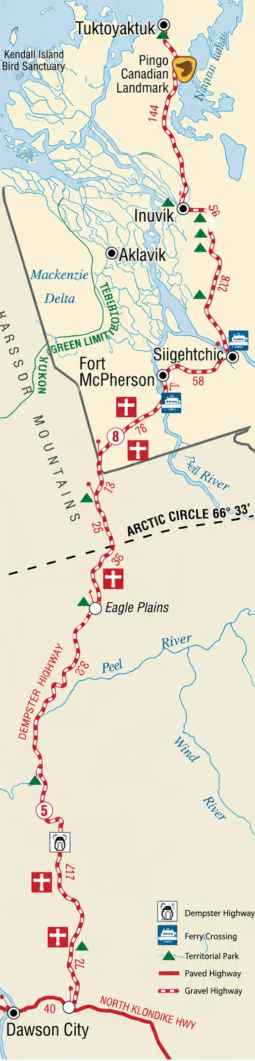

Tuktoyaktuk nestled on the shores of the Arctic Ocean is home to Parks Canada’s “Pingo National Landmark” – a collection of ice hills.
Inuvik awaits you at the end of this year-round highway, offering a full range of services and facilities. The Western Arctic Visitor Information Centre is open from the third weekend in May to mid-September. It features both indoor and outdoor interpretive displays about the whole Delta region and is a worthwhile destination in itself. Information on trips to all the outlying communities and other attractions are available from here.
Inuvik’s Happy Valley Territorial Campground offers 27 sites, with laundromat, nightly fee and 24-hour security
Just outside the community of Inuvik, Jak Park Campsite offers 36 sites, with a fee for overnight or day use, and 24-hour security
Twenty non-powered RV sites and four tent sites.
It is a short walk from the road to the edge of the cliffs that overlook Campbell Lake, which is an example of a reversing Delta. The cliffs are home to raptors such as Peregrine Falcons.
Vadzaih Van Tshik Campground has 11 sites.
Tsiigehtchic is a traditional Gwich’in community, where a more relaxed pace of life may still be found.
The Mackenzie River and Arctic Red River ferry is free and operates 9:00 a.m. to 12:30 a.m. daily, June to mid-October. Cross by ice bridge in the winter from the end of November until April30. The flow of the Mackenzie River, draining one fifth of Canada, over 1,800,000 sq. km. (700,000 sq. miles), is exceeded in the western hemisphere only by the Mississippi and the Amazon. The Mackenzie Delta is the largest in Canada and the tenth largest in the world.
Fort McPherson offers a good range of basic services, the Tent and Canvas workshop, open 9 to 5 weekdays, and a self-guided tour of the community
Nitainlaii Territorial Park campsite (23 sites, nightly fee) and its visitor information centre are open from June 1 to September 1. The centre offers fascinating displays of the traditional lifestyle of the Gwich’in people of the region
A view of the Mackenzie Delta and Peel River valley.
Note the time zone change at the Yukon/NWT border crossing – set watches one hour ahead when travelling north, back when going south. There is an interpretive display here worth seeing that describes the local wildlife and landscapes.
Twenty sites offer sheltered protection within a steep gorge of the Richardson Mountains.
Catch a photo of yourself crossing the Arctic Circle, taking a moment to see the displays that explain the Arctic Circle and the northern lights. From this latitude northwards the sun never sets at the summer solstice, June 21, and never rises at the winter solstice, December 21.
The halfway point. The hotel, Ph (867) 993-2453, open year round, offers a licensed restaurant and lounge, full service garage with propane, petro, diesel and licensed mechanic, tire sales and repair, and limited aircraft facilities. Next services – Fort McPherson 193 km (120 miles).
Ogilvie Highway Maintenance Camp.
Located at the foot of Sapper Hill, a sharply eroded limestone ridge with fascinating rock ‘forests’. Eight sites and good �ishing
The highest elevation on the Dempster, at 1,289 metres (4,229 feet). First crossing of the Continental Divide.
Take in the panoramic view west to Tombstone Mountain, some 40 km (25 miles) away
Tombstone Mountain Campground, with 22 sites, offers nature walks and campfire talks, in July and August, and a staffed interpretive centre. It is a base for hikes into the Tombstone range.
Klondike Highway Maintenance Camp.
Take in the Gateway interpretive display at the unction of the Dempster Highway with Yukon Route 5, 40 km (25 miles) east of Dawson City. It’s 365 kms (232 miles) to the next services at Eagle Plains.
Before you start your journey up the Dempster, be sure to stop in at the Dempster Delta Visitor Information Centre on Front Street in Dawson City, Yukon. See the excellent displays and meet our friendly travel counsellors, who can help you plan your trip. Open from the third weekend in May to mid-September.